“The AI capability oil and gas operators spent a decade refining for hydrocarbon interpretation transfers cleanly to geothermal. The pivot doesn't require a new ML team - it requires repointing the existing team at new training data.
”
Major oil and gas companies have been scrambling to make ambitious climate commitments - pivoting capital to clean energy, signing net-zero pledges, ramping up solar and wind portfolios. Renewable energy - derived from natural processes that replenish at a rate equal to or faster than consumption - is the destination.
Sun, wind, biomass, geothermal, hydro, ocean, biogas, and liquid bio-fuels are the standard candidates. Among them, geothermal has been quietly rising in profile because it solves a problem the others don't: it provides baseloadContinuous power generation that runs 24/7 - the opposite of intermittent sources like solar (off at night) and wind (off on calm days). Geothermal's strategic edge in the renewables mix. power. Solar stops at night. Wind stops on calm days. Geothermal runs continuously.
Roosevelt Hot Springs case - model summary
Facies classes the network learns to segment from a single 2D section
Training patches generated from inlines 1-271 (40×40 with stride 10)
Epochs to convergence on a single GPU
Pixel accuracy on the held-out test slice - comparable to expert interpretation
This piece walks through how the deep-learning toolkit operators have spent a decade refining for hydrocarbon-reservoir interpretation can be redirected to find geothermal reservoirs - using a real case study from the Roosevelt Hot Springs Geothermal Area, Utah.

What geothermal power plants actually are
Geothermal power plants generate electricity from the Earth's internal thermal energy - the heat stored in the mantle and propagated to the crust by conduction and convection. Mechanically, they're not exotic: instead of a coal-fired boiler or a nuclear reactor, the heat source is the Earth itself. The plant is fed by hot water or steam extracted through wells. Used water is typically reinjected to the formation; make-up water is needed because extraction rates exceed return rates.
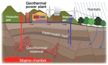
The headline operational difference from oil & gas: the resource is heat, not fluid. The fluid is just the conveyor. That changes the geophysics priorities - you care more about temperature gradients, fault permeability, and fluid circulation patterns than about porosity-volume products.
The Roosevelt Hot Springs case
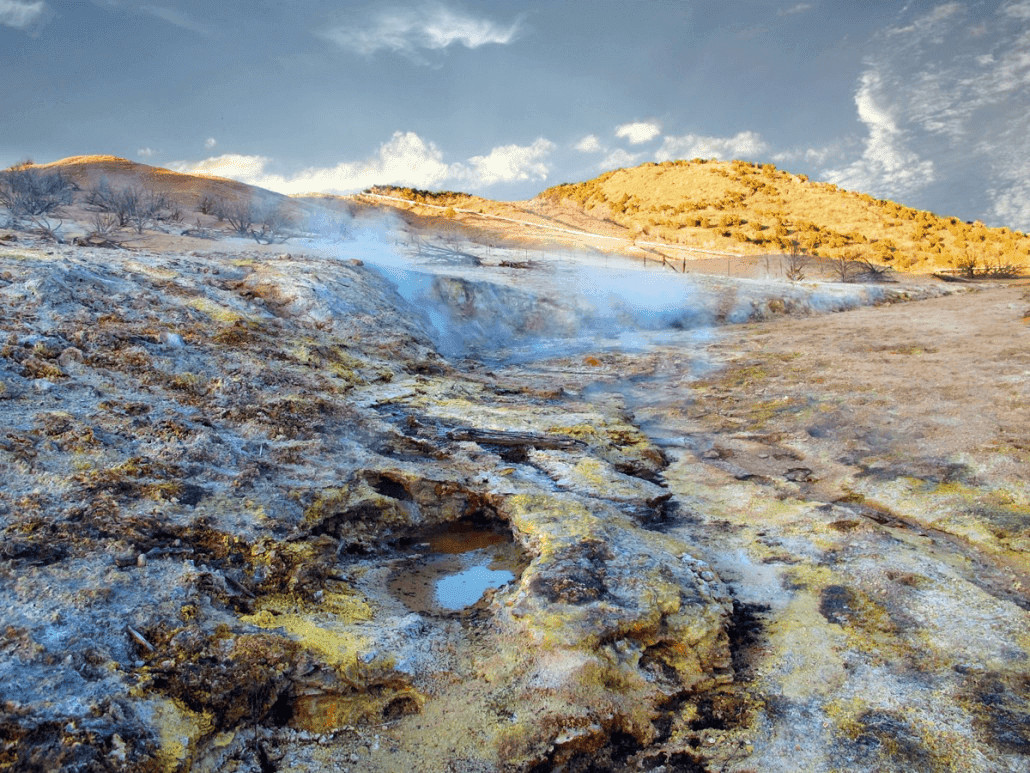
The Roosevelt Hot Springs Geothermal Area in Utah is a major hydrothermal reservoir whose architecture is structurally dominated by a fault intersection. Two predominant features constrain the reservoir:
- The Opal Mound Fault - a major north - south structure
- The Negro Mag Fault - east - west, intersecting the Opal Mound
The recorded flow at one of the surface hot springs has decayed dramatically over the last century. The decline does not happen all at once - flow collapses first, temperature follows, surface expression dies last:
Roosevelt Hot Springs · Surface decline
From 38 l/min to dried-up in 58 years
Hover any point. Flow collapses first; temperature follows when the surface expression loses contact with the deeper heat source. The reservoir is still active at depth — what changed is which fault zone is conducting the fluid.
The proposed heat source: a plume of partial-melt material underlying the central to western Mineral Mountains. The decline pattern at the surface is consistent with subsurface flow being increasingly captured by deeper, cooler fault zones - a classic reservoir-management problem in reverse, and one where high-quality seismic interpretation matters most.
Where AI fits - automating seismic facies identification
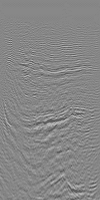
The bottleneck in characterising any seismic reservoir, geothermal or otherwise, is interpretation throughput. A senior geophysicist labelling 8 faciesDistinct rock characteristics inferred from seismic reflection patterns - the geological 'units' an interpreter labels. Eight facies classes is a typical labelling resolution for a structurally complex reservoir. classes across a 3D volume by hand is the traditional approach. It's slow, inconsistent across interpreters, and doesn't scale to repeat surveys.
The AI alternative trains a deep neural network on a small annotated subset and lets the network propagate the interpretation across the full volume - a task technically known as semantic segmentationPer-pixel classification - assigning each pixel of an image to one of N classes. In seismic interpretation, the classes are facies (rock-type interpretations); in medical imaging, they're tissues or pathologies..

Training pipeline - concrete numbers
For full reproducibility, the training pipeline used on Roosevelt:
- Source data: processed 2D seismic, annotated and segmented into 8 facies classes based on prominent horizons.
- Section sizes: 643 × 271 and 250 × 271.
- Patching: 40 × 40 patches with stride 10 (instead of the conventional half-patch stride of 20). Trades training time for training-set richness.
- Train/val/test split:
- Train: inlines 1-271 → 2407 patches (20% held out as validation = 482 patches)
- Test: inlines 272-321 → 122 patches
- Augmentation: random rotation ≤ 10°, random noise injection, random horizontal flip
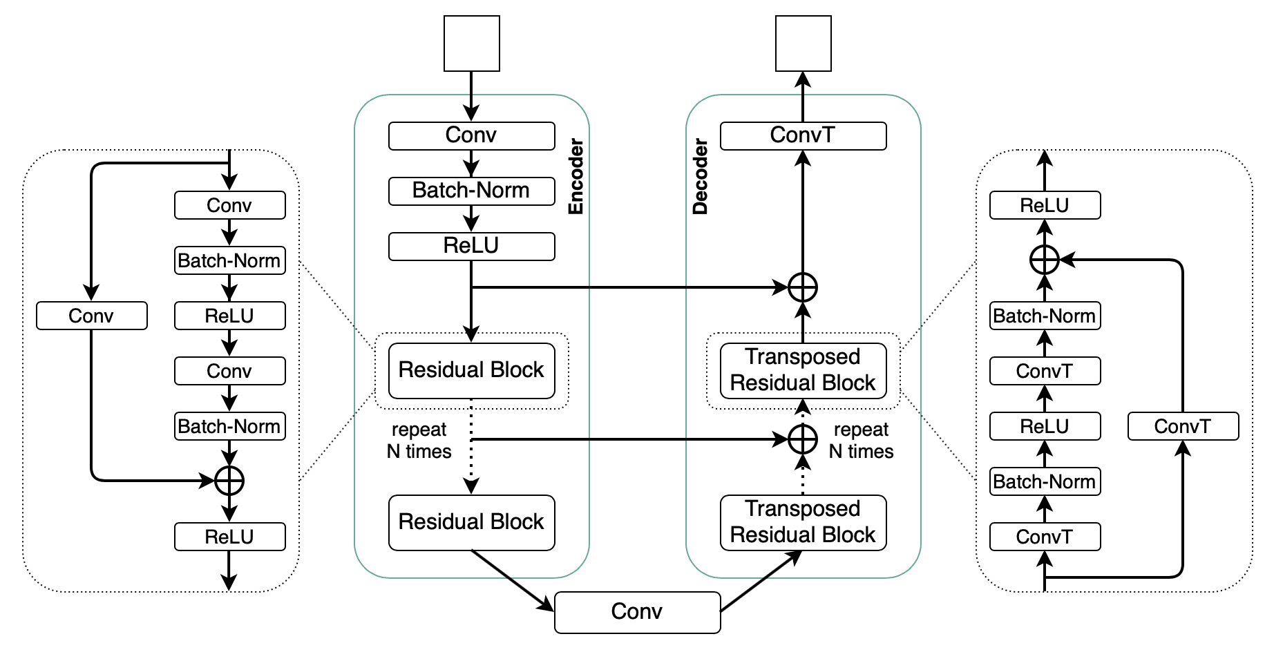
- Architecture: EarthAdaptNetEarthScan's residual encoder-decoder network for seismic facies segmentation. Uses residual blocks in the contracting path and transposed-residual blocks in the expanding path, with U-Net-style skip connections preserving spatial detail. - encoder-decoderA neural-network architecture that first compresses an input image to a low-dimensional feature representation (encoder), then expands it back to per-pixel predictions (decoder). Standard backbone for semantic segmentation in seismic interpretation. pair, full paper forthcoming
- Optimiser: Adam, learning rate 1×10⁻³
- Loss: cross-entropy
- Batch size: 32
- Training: 50 epochs
These numbers aren't ceremonial - they're the right starting point for anyone trying to reproduce this on a new geothermal area. Patch stride and rotation augmentation in particular were both load-bearing for the test-set numbers we saw.
Results - predicted vs interpreted horizons
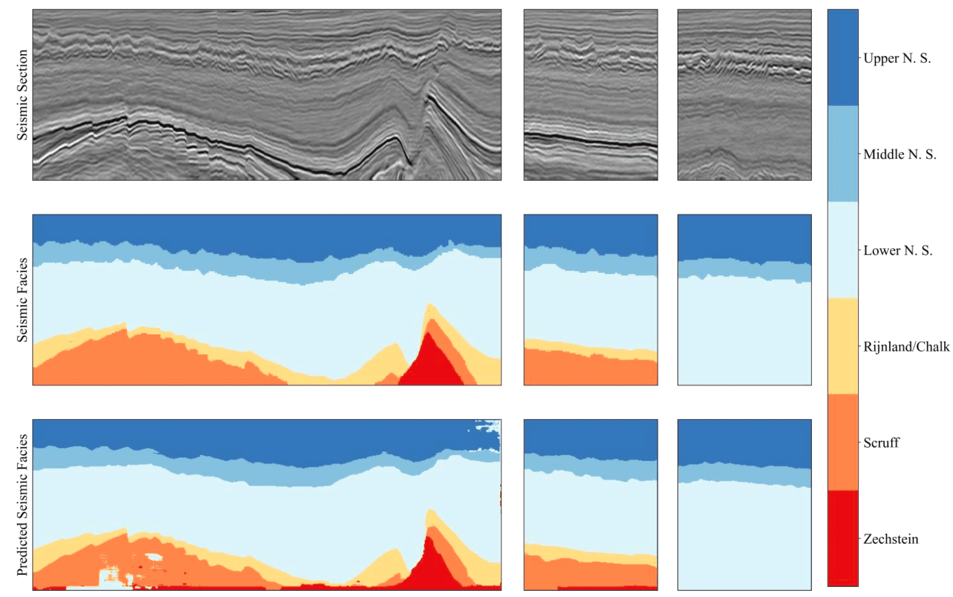
Three views of the test section side by side:



The network reproduces the major horizons cleanly. Where it disagrees with the expert interpretation, the disagreement is on fine-grained facies boundaries near fault intersections - exactly the regions where two interpreters disagree with each other.
The AI alternative is not a replacement for the geophysicist - it is a force multiplier. A senior interpreter spends their time on the hard, ambiguous regions; the network handles the volume.
Why this matters for the energy transition
Two takeaways:
The skills transfer. Every AI capability oil & gas operators have built for hydrocarbon exploration - seismic interpretation, log digitisation, fault detection, reservoir characterisation - has a direct analogue in geothermal. The pivot doesn't require a new ML team; it requires repointing the existing team at new training data.
Data is the bottleneck, not algorithms. Geothermal projects today have far less seismic coverage than mature oil & gas basins. Self-supervised pretraining on the much larger oil & gas archives, followed by fine-tuning on geothermal sites, is the obvious path forward. We're publishing on it.
The full EarthAdaptNet paper covers the architecture in detail. Stay tuned.
Key takeaways
- Geothermal solves the problem solar and wind don't - it provides baseload power, 24/7.
- The AI toolkit oil & gas operators built for hydrocarbon interpretation transfers cleanly to geothermal - repoint the team, don't rebuild it.
- The Roosevelt Hot Springs decline is the textbook signal: flow collapses first, temperature follows, surface dies last - exactly the pattern automated seismic facies interpretation can detect early on a new geothermal target.
- Data, not algorithms, is the bottleneck - geothermal projects today have far less seismic coverage than mature oil & gas basins. Pretrain on the larger archives, fine-tune on the geothermal sites.
Glossary
- Baseload
- Continuous power generation that runs 24/7 - the opposite of intermittent sources like solar (off at night) and wind (off on calm days). Geothermal's strategic edge in the renewables mix.
- EarthAdaptNet
- EarthScan's residual encoder-decoder network for seismic facies segmentation. Uses residual blocks in the contracting path and transposed-residual blocks in the expanding path, with U-Net-style skip connections preserving spatial detail.
- Encoder-decoder
- A neural-network architecture that first compresses an input image to a low-dimensional feature representation (encoder), then expands it back to per-pixel predictions (decoder). Standard backbone for semantic segmentation in seismic interpretation.
- Facies
- Distinct rock characteristics inferred from seismic reflection patterns - the geological 'units' an interpreter labels. Eight facies classes is a typical labelling resolution for a structurally complex reservoir.
- Hydrothermal
- A geothermal system where heated water or steam is the working fluid that conveys subsurface heat to the surface. Distinct from petrothermal systems (engineered fracture networks circulating cold-injected water through hot dry rock).
- Opal Mound Fault
- The major north - south structural fault at Roosevelt Hot Springs, Utah. Together with the east - west Negro Mag Fault, it controls reservoir geometry and constrains fluid migration paths.
- Semantic segmentation
- Per-pixel classification - assigning each pixel of an image to one of N classes. In seismic interpretation, the classes are facies (rock-type interpretations); in medical imaging, they're tissues or pathologies.