MEM-1DREADY
1D Mechanical Earth Model
Stress profiles, pore pressure and elastic properties from DLIS and FMI.
The subsurface decision workspace.
An AI-native geoscience platform that ingests LAS, DLIS and SEG-Y, builds mechanical earth and 3D models, and reads well logs at archive scale. Fourteen modules in one workspace, on the model you choose: Claude by default, Cerebras for speed, or Hominis v3 fully on-prem.
Real screens throughout this page: the live application working on public Texas and NW Shelf well data.
Load the data and EarthScan does the rest. Three workflows below, every screen the real application on public well data: discovery from raw files to a ranked recommendation, geomechanics on the same graph, and the paper archive brought back to life.
Drop LAS, DLIS, SEG-Y or CSV, a whole folder at once. Every well, borehole, log, formation and field becomes a node; the relationships between them become edges. There is no schema to define up front, it forms as the data streams in.
EarthScan proposes new node types and relations from what it just read, and unifies the same well seen across LAS, DLIS and SEG-Y. One click enriches the graph; there is no data-modelling step.
The graph lands on an interactive map so well coverage reads geographically. Group by field, filter by data type, then box-select the wells of interest: hover this panel and nine wells are picked, ready to correlate. No dialogs, no export.
The same correlation through three lenses: an analog graph, an auto-built cross-section and 3D. The tops and ties are picked by EarthScan rather than drawn well by well, and the agent rings its best analog.
Correlation groups are ranked by net pay, PI and well support, and the answer arrives in plain language with its confidence and full reasoning shown. It is honest about uncertainty: a low-support pick is flagged as a lead, not a call.
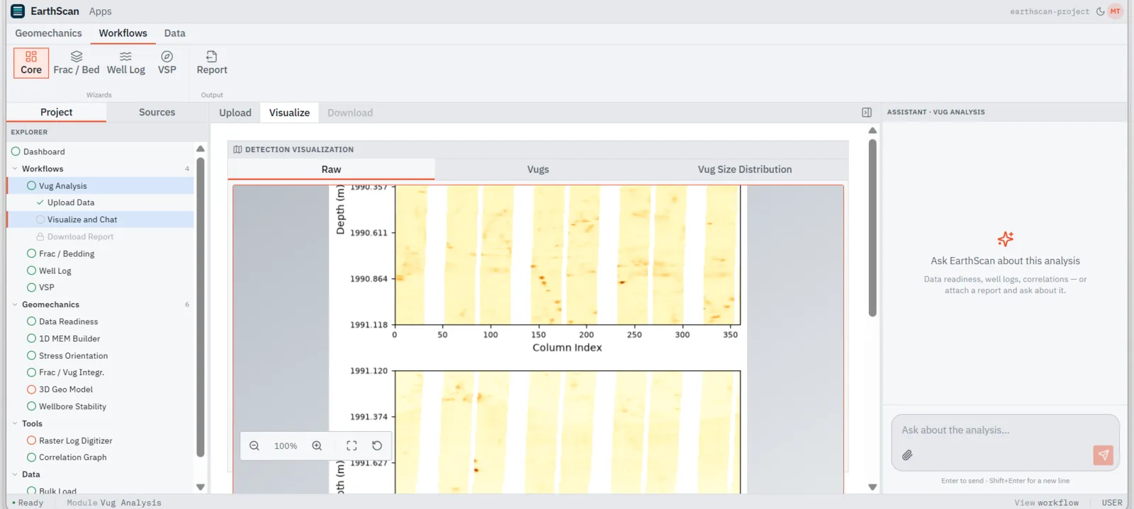
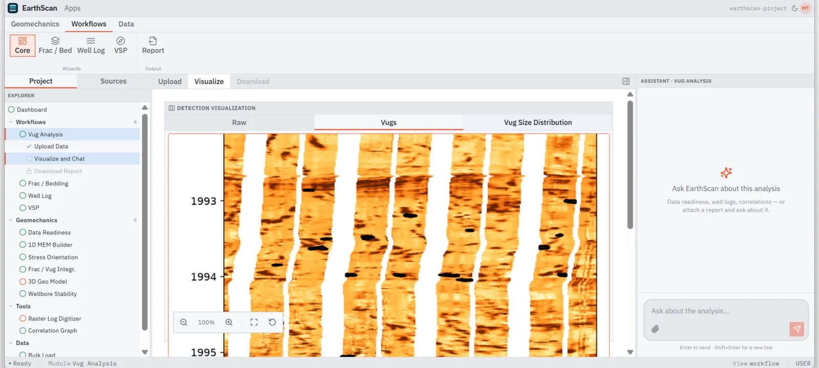
The FMI image log goes in exactly as recorded. Drag the divider and the detection overlay appears: every vug picked in place by the engine, with no manual tracing.
Fifty-six drilling-induced fractures and thirty breakouts resolve into a rose diagram, a SHmax call of N70E and a strike-slip regime, cross-checked against the World Stress Map.
Open fractures, cemented fractures and vugs are counted, profiled against depth and fed straight into a discrete fracture network, with vug-corrected elastic properties.
A Jaeger-PWM dip classification sorts the fracture inventory and flags the sets critical for lost circulation, ready for the DFN.
A stability-index profile runs against the collapse and fracture gradients; the at-risk interval is listed with its depths and a mud-weight guardrail.
A context-aware chat travels with every module and retitles itself to the analysis on screen. Ask about the numbers in front of you and it answers from that analysis, not from a generic model. Attach a report and ask about that too.
Decades of wells exist only as scanned images. The digitizer finds the header and tracks, splits them, scores its own confidence and hands back numeric curves, LAS-clean, into the same graph as everything else.
Every capture below is the real application at work: real wells, real logs, real detections, straight from the workspace. Click any surface to inspect it at full size.
Stress profiles, pore pressure and elastic properties from DLIS and FMI.
Rose diagrams resolve SHmax N70E from 56 DITFs and 30 breakouts, cross-checked against the World Stress Map.
A stability-index profile against collapse and fracture gradients, with risk zones and mud-weight guardrails.
The correlated wells in a volume, driven from a stratigraphic navigator with horizons, seismic and production.
FMI-derived secondary porosity fed into a DFN: 55 vugs, 60 open fractures, vug-corrected elastic profiles.
Multi-track curves against depth with auto-picked horizon tops and a lithology column.
Reads the raw FMI image log and picks fracture and bedding-plane sinusoids in place.
Secondary porosity detected on the borehole image, no manual tracing. Hover to see the raw input.
Checkshot velocities and corridor stacks from vertical seismic profiles.
An auto-built cross-section: facies correlated across wells without hand-picking a single top.
Drop LAS, DLIS, SEG-Y, ZIP or SHP; a geological knowledge graph builds live in your browser. Files never leave the machine.
Connect a drive or drop files; parallel parsing routes each format to the right module.
Scanned paper logs become vector LAS through a two-stage detection pipeline.
Portfolio-wide subsurface intelligence on one screen: lead basemaps with structural contours, risk-factor scoring, volumetrics and chance of success, with the cross-section underneath. Here: seven leads ranked, Osprey-N at 34% chance of success and 16 MMbbl risked P50. Rank the portfolio and defend the drill decision from a single screen.
Every analysis, chat and agent run routes through the LLM you select. Swap it per project, or pin the sovereign path and never let a token leave the estate.
The workspace default. Deep multi-step geoscience reasoning, running through your own Anthropic key so usage stays on your account.
The workspace assumes your data is sensitive, your competitors are close and your auditors are closer. The defaults are set accordingly.
Run Hominis v3 inside your perimeter, on hardware you control.
BYOK across providers. Model traffic runs on your accounts and your contracts.
GeoKG builds its knowledge graph client-side. Raw files never leave the machine.
Every operator works in a hard-isolated space. Competitors never share a boundary.
Access to EarthScan 360° AI is reserved for verified operators. Sign in with Microsoft, LinkedIn or your corporate email; every request is reviewed and approved by our team before access is granted, which keeps competitors and rogue actors on the outside of the door.
This is the 360° AI platform login. Client project spaces are separate and keep their own entrance.